Future of SAP and Spatial and why should you care? Part 2
On Part 1 of this blog we gave you a bit of an intro to GIS/Spatial and told you about the great things SAP is doing with spatial already using HANA plus a little bit more on how Esri and SAP have partnered together to create the best of breed (best from both worlds) integrated GIS & ERP story.
On this Part 2, we dive into what is expected to happen in the near future with SAP Spatial too; a lot of this is already happening and we will showcase some examples when that is the case. A lot of the changes are quite fundamental and as such require a lot of changes to people’s processes and workflow, technology is easy, but people and processes are not.
We will look more closely at SAP Spatial and Esri, what has already been integrated and what are the roles of these two organisations on their joint venture. And of course, what is the Zag Spatial story on all these exciting future ventures!
The Undiscovered Country (Future)
Everybody talks about how it is all about People in today’s IT environment, but I would like to go a step further and say it is actually all about ME as we are on the verge of the ME-generation emerging into the workforce. So, we all need to look at our business visions, aspirations and capabilities and link them with ME-mentality – how do these serve our customers and people when they are going to emerge with self-centric activities.
Everybody talks about how it is all about People in today’s IT environment, but I would like to go a step further and say it is actually all about ME as we are on the verge of the ME-generation emerging into the workforce. So, we all need to look at our business visions, aspirations and capabilities and link them with ME-mentality – how do these serve our customers and people when they are going to emerge with self-centric activities.

|
ME-generation and embracing the individuality is all about:
|
Note that I do not see this as a negative thing, it is just different way the world is going to be working from now on, so let me give you some examples on how I see the future working using some familiar sci-fi movies as baseline …
You remember that moment from Minority Report where Tom Cruise walks into a shopping mall with ads changing for him specifically:
You remember that moment from Minority Report where Tom Cruise walks into a shopping mall with ads changing for him specifically:

This technology is already here and is done using things like iBeacons (or Beacons from non-Apple vendors) - https://clevertap.com/blog/beacon-marketing/
For example, retail chain Target uses beacons to show your location on mobile map/app rather than just as a guide on the corridors or a piece of a paper map. Another retail chain Nordstrom uses beacons to inform you when passing their outlet in the shopping mall or on the street even driving your car if they have your mobile basket item in stock. Retail giants CVS Pharmacies and Walmart push notifications on offers to customers based on their shopping habits, prescription notices etc. while they are walking the shop corridors in real-time.
How about that moment from Total Recall (the remake) when Colin Farrell used the augmented hand-phone the first time – calling with it plus pressing it on sensor glass to get the full video view:

Well, that technology is here already too, RFID tags are embedded under people’s skins; for example, in the Nordic country of Sweden, thousands of Swedes have had RFID tags planted under their skin and can use them for public metro travel, instead of tickets or key cards. Almost here are augmented vision and smart drugs, see this link: https://bigthink.com/10-human-body-modifications-you-can-expect-in-the-next-decade. Then there are these more bizarre augmented humanity experiments like this video of a third thumb project: https://www.youtube.com/watch?v=fH67RH6_rwI.
Augmented humanity accessories and smart drugs send a whole lot of information to the cloud already (including a GPS location) and are going to be the basis for future micro-transactions, micro-services and ‘moments’. According to Gartner, these are a full workflow mechanism supported by a combination of analytics, AI, automation, sensors and smart devices/clothing/smart medicines to seriously boost emergency recovery scenarios and reduce time needed for agencies to attend a crash site or an emergency situation.
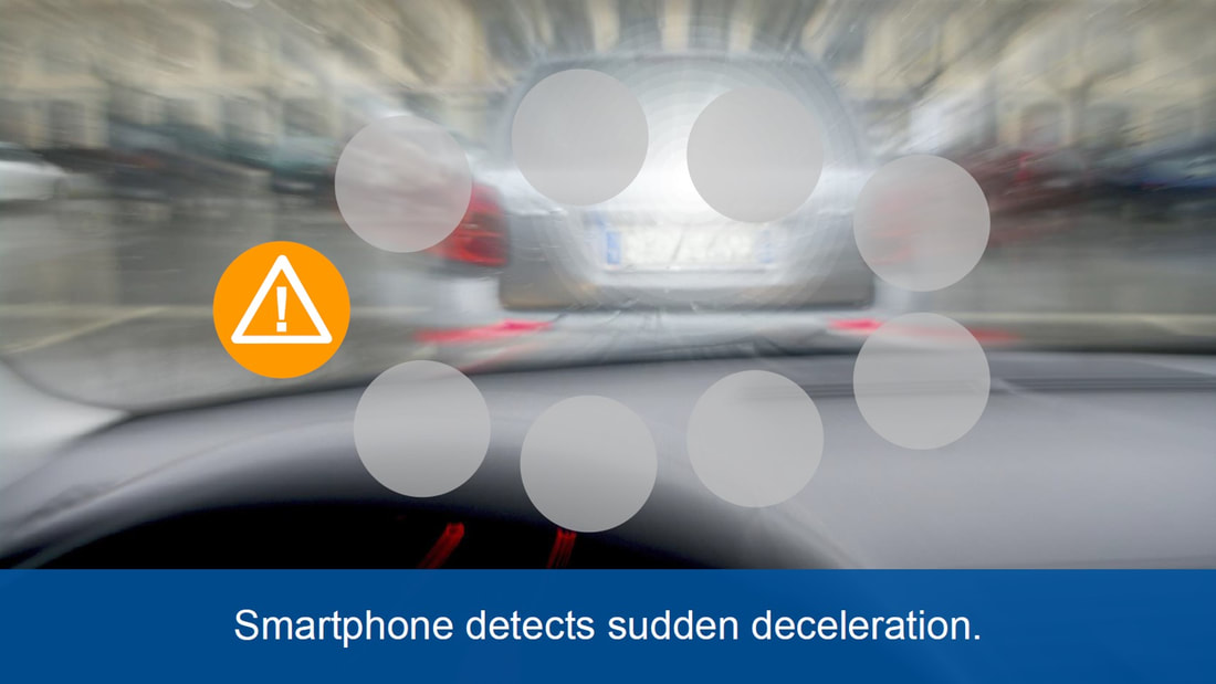
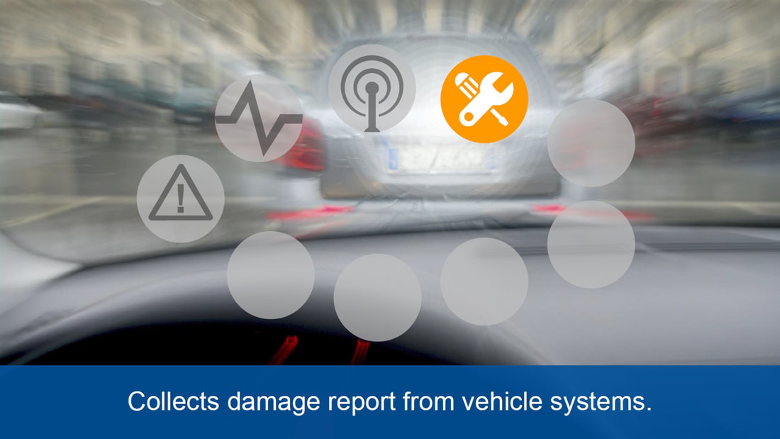
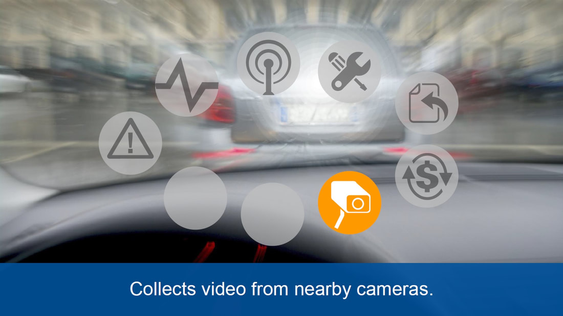
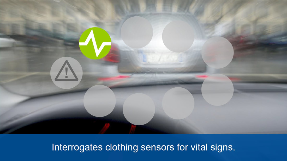
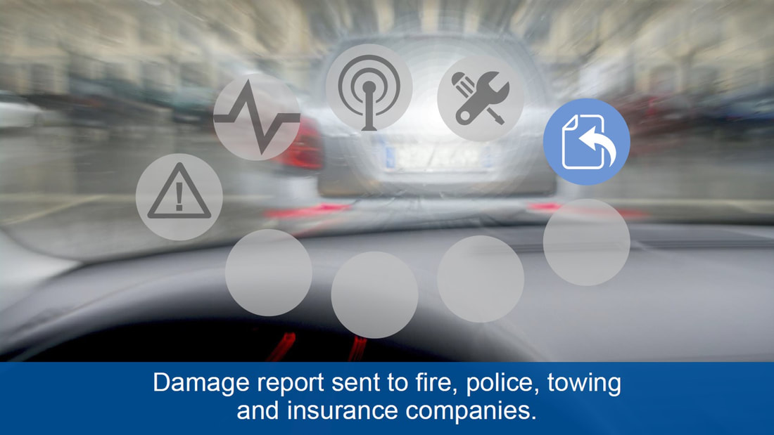
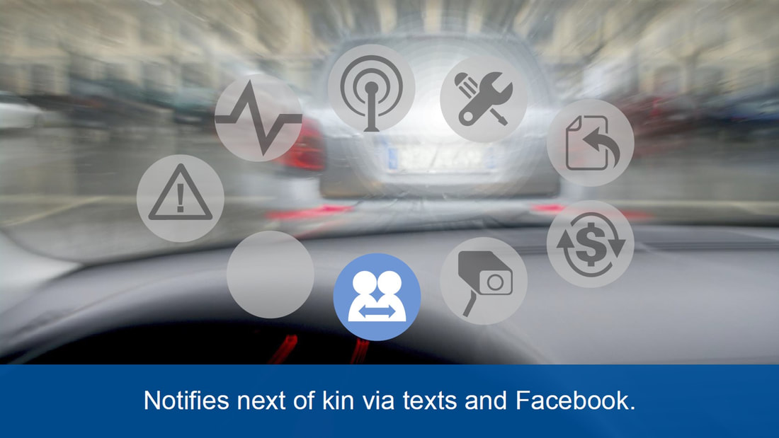
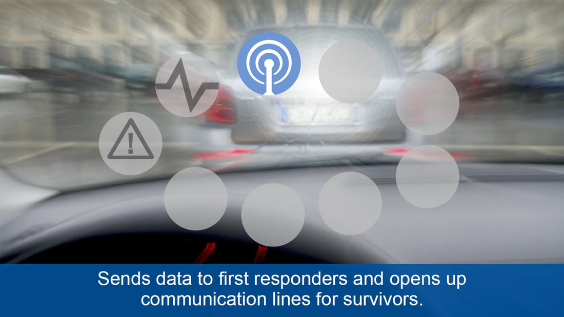
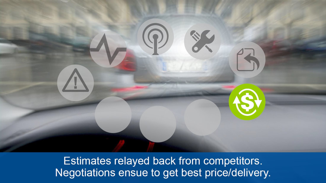
Consider the following series of moments on a traffic crash incident (sequence: left-to-right, down one then left-to-right again):
Augmented humanity accessories and smart drugs send a whole lot of information to the cloud already (including a GPS location) and are going to be the basis for future micro-transactions, micro-services and ‘moments’. According to Gartner, these are a full workflow mechanism supported by a combination of analytics, AI, automation, sensors and smart devices/clothing/smart medicines to seriously boost emergency recovery scenarios and reduce time needed for agencies to attend a crash site or an emergency situation.
Consider the following series of moments on a traffic crash incident (sequence: left-to-right, down one then left-to-right again):
|
|

|
This is a potential example of a traffic accident automation showing how automated devices and AI scripts manage the process of efficiently organising everything around your incident.
So, what’s happening at this moment? You are part of a connected network that includes your vehicles, devices and everything else around you. All these objects work as sensors that can capture real-time information about you and what is happening around you. So, sensors can translate accurately what has happened to you. For example, even though they cannot tell that you were distracted while driving a car - and that is why you crashed (they cannot read your mind), your car can tell how you were driving and whether you made a mistake (or somebody else did), your augmentation and smart medicines inside your body can tell if your heart rate changed or your brain was stimulated with something other than expected when driving.
This information is communicated with wider AI entities to organise an ambulance, police, insurance to cover for the costs and even social media to inform your friends and family.
Informing via Social Media (messaging to next-of-kin via Facebook) is especially telling as it’s a neat example of a kind of ‘alienation’ that could possibly become the ‘norm’ with the ME-generation.
Please note that some of the things I mentioned above are additional steps I felt weren’t considered such as a check on the smart medicines or under skin medical devices that could be checking anomalies, damage and vital signs and report that to doctors or an ambulance.
This is all about ME and about sharing and shedding responsibilities as AI and agencies are involved straight away sharing the responsibilities, whereas you’re shedding responsibilities as you want somebody else to take care of all this not you. In this case, you’re letting machines do all the work.
Emerging Technologies - Coming to the SAP World Too
Slope and aspect, contours and 3D cadastre are becoming important for asset management, so much so that soon you won’t be able to get the data in 2D anymore. Spatial has matured enough to enable for the models from the CAD world to be natively accessed in GIS tools like ArcGIS Professional and transformed to be used with Augmented, Virtual and Mixed Reality (AR, VR, MR).
|
|
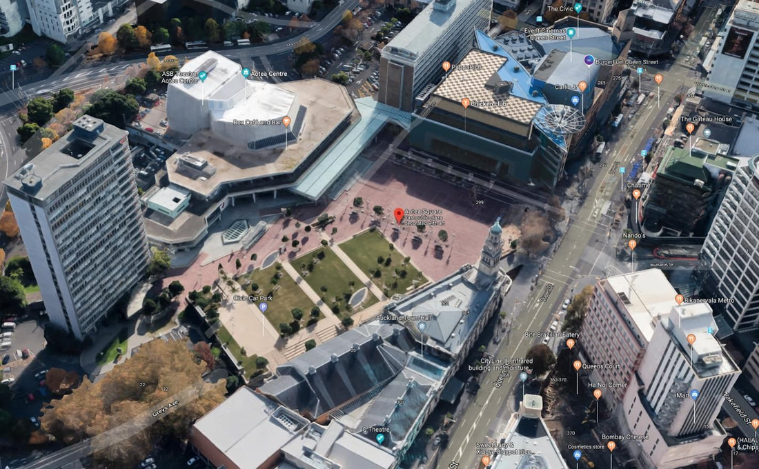
You can highlight changes or trends on a 3D map the same way you would on a 2D map. For example, see the solar exposure slider on wellington central on the right. This kind of heat map would be quite meaningless with a traditional 2D map.
|
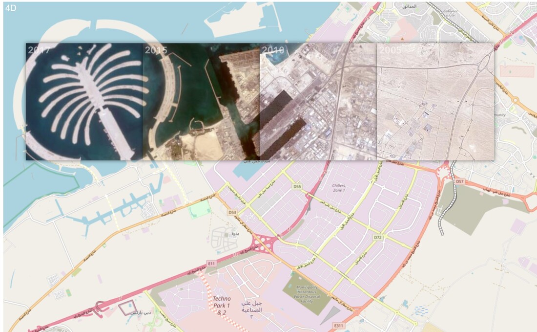
Other dimensions are also emerging – for example 4D is all about time series, showing the change on assets across time (using time sliders etc.).
Historical data can be applied to 2D entities and maps too – a good example is the picture to the left, using satellite imagery of various ages and seeing the historical imagery through a lens on top of a standard vector base map. Note that there are 4 history lenses shown on the image. |
Please note that slope and contour are provided through something called 2.5D – that’s an automated build of a 3D environment using 2D data. For example, wrapping aerial imagery around 3D slope/contour as well as on large buildings rendered on top of aerial imagery to provide the land and buildings the actual look. This is for example how Google Maps does their 3D map rendering and is perfectly adequate for most of the people but not good enough for surveying and construction.
|
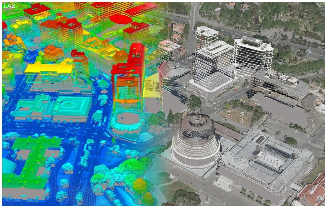
One of the neat new ways of using 3D is indoor building viewing that allows for assets to be viewed via slicing through building walls and floors.
For example, the view on the left is from Esri Web App Builder using web browser interfaces to allow users to slice through airport facilities. The image is animated showing slicing through the indoors. |
And going beyond these ways of viewing and manipulating maps, the next wave is already happening, and it’s about the automation of pulling out vector data (what’s changed for example) from satellite/aerial imagery (2D) and LiDAR (3D).
Alternative ways of viewing reality are everywhere. The easiest way is to do it is via your mobile, but there are more and more tools to do this, and human augmentation will include some of this too; think of images being reflected direct to your retina and/or audio directly to your ear canal.
To understand the different ‘realities’, consider the following simple formula:
Mixed Reality (MR) = Virtual Reality (VR) + Augmented Reality (AR)
All three “realities” are often used in sequence starting with engineers modelling real-world and assets using Virtual Reality, then field testers checking the changes and/or new entities using Mixed Reality and eventually enabling all of this for customers using Augmented Reality.
1. VR (Virtual Reality)

|
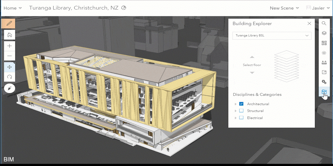
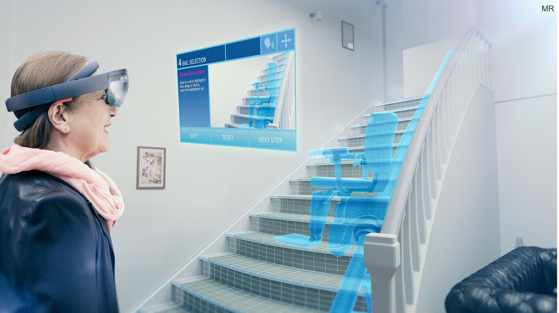
Virtual Reality today is mostly about CAD designers/engineers using virtual modelling device like HoloLens and CAD tools specifically designed for those devices with non-projected CAD drawings (so you can locate the 3D drawing anywhere).
These can be blown out to view on a real scale, but not usually where they will be built in. |
2. MR (Mixed Reality)
|
Mixed reality takes the VR model, attaches actual ground coordinates into it to allow field testing on the ground.
This is so we can see that the design works as planned on top of the real-world assets and entities, giving us a view on how this would look once it is built and what the view would be for the users of augmented reality. |
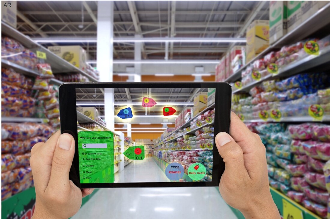
3. AR (Augmented Reality)
|
Augmented Reality views the world through a lens like a smartphone or a tablet and shows additional information on top of these assets.
It can also show simple virtual symbols, icons or polygons. For example, enabling field workers to capture hazards like asbestos on ceilings, or the training industry highlighting 3D machinery with sequential written instructions on how to fix/manipulate these machines. |
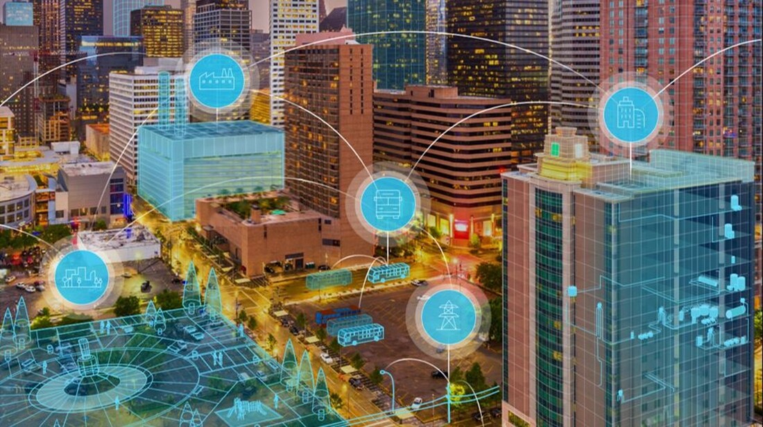
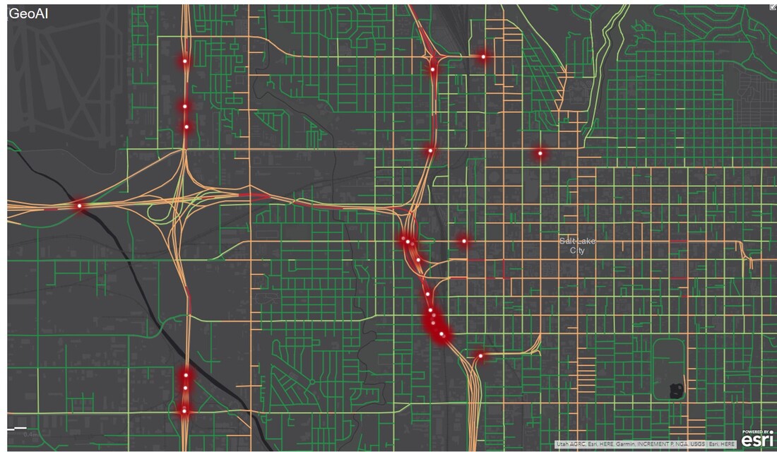
We are starting to realise the value of connected networks (Connected Everything and Everything as a Service) and how much more efficiently we can manage our cities when we use technologies like sensors, Internet of Things, Digital Twins and GeoAI.
|
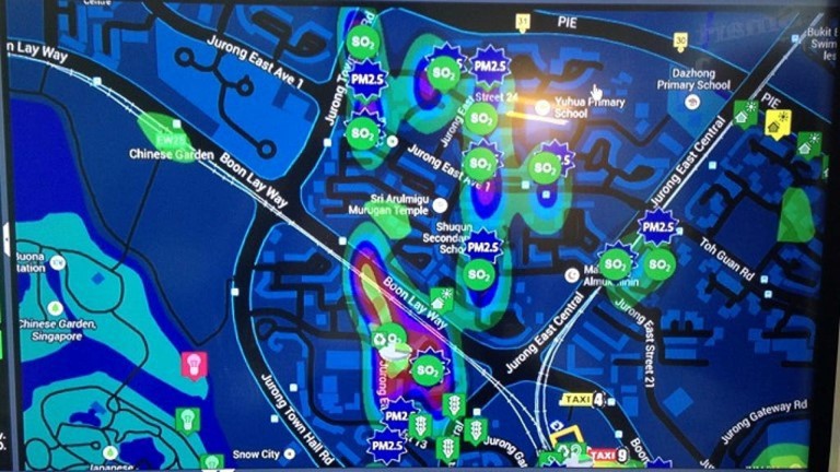
Sensors & Internet of Things (IoT) in urban and rural environments both indoor and outdoor are location aware. Take Singapore, the world’s first real Smart City with sensors on trees, buildings, city assets, roads, traffic signs etc. measuring everything; the humidity, the temperature, CO2 & SO2 levels, noise, video capture across the whole city, image recognition in metros and motorways.
The list goes on. |
Digital Twins are created against entities like buildings, city assets and even workflows like traffic and most of them are Spatial.
|
A twin is usually against an asset but can be even a whole city; SAP has built something called SmartCitiesWorld, a platform for Smart Cities (kind of a Digital Twin of a city) based on HANA, Spatial Services and IoT services. This has been implemented in several cities, including; Nanjing in China and San Diego in the US.
All the spatial components in it are enabled using Esri and HANA. |
Digital Twins together with advanced geospatially enabled AI (GeoAI) can be a great help for queries, reporting and monitoring.
|
But it is good to understand that GeoAI is much more than just Image Processing or bringing some sensor data into a map.
For example, it’s algorithms predicting where crime or accidents are going to happen, or pulling Big Data from other sources like Social Media into the mix, and even building AI learning algorithms to figure out what works and what doesn’t using connected data. |
Going back to the SAP SmartCitiesWorld product example and to the city on Nanjing, China, that is collecting and monitoring all the IoT devices (vehicles, drones, asset sensors etc.) to collect the following;
|
|
These monitored attributes are used on various dashboards to provide a constant real-time feed of information, alerts and notifications:
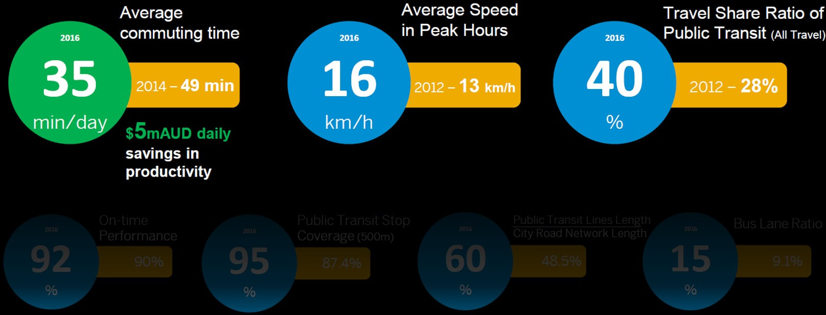
Colour-coding is used to show where improvements are needed, historical figures on the side to show trends to positive or negative. Anything can be drilled down on to get more detail on how the city is doing.
Future Hardware/Software
There are a lot of things to be excited about with on the technology side, but the timeline below showcases 4 things that are interesting from a spatial perspective.
Future Hardware/Software
There are a lot of things to be excited about with on the technology side, but the timeline below showcases 4 things that are interesting from a spatial perspective.
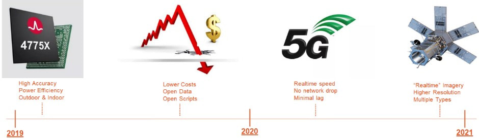
The first one has already happened and is a new GPS chip-set that improves XY accuracy from 5-10 meters to 30cm and the Z accuracy (height) from 30-50 meters to 30 cm. So goodbye to dongles that were required on the end of your device or optimisation servers in the back office to boost accuracy. Goodbye to some jobs that were built upon these now obsolete technologies.
Note that this chip-set uses significantly less power than the older chip-sets and can use lower range satellites meaning it works equally well indoors and outdoors. Currently, it’s only supported by the latest Chinese mobiles Huawei and Xiaomi but has been promised in the new Samsung and Google devices coming soon.
Something that is happening globally, and due to happen locally eventually, is more open data initiatives bringing the mobile and wireless data costs down. Free services (for NZ scale) are emerging, targeting large customers, but, unfortunately, NZ seems to be too small – although we remain hopeful. Satellite companies like Maxar are opening their rules-engines. We can see evidence of that with SAP Spatial Services in the use of satellite imagery and AI scripts provided. The AI scripts will become open source eventually.
5G is coming, 5G is coming! It will boost performance significantly across the whole country. There are even guarantees that the network will never drop (based on mathematics) and lag will be minimised. I’m cautiously excited about these, after all, New Zealand is a water-locked island nation with lots of mountains.
Maxar (ex-Digital Globe) has promoted their 30cm ‘near real-time’ offering for satellite imagery for the whole of NZ already We have been trialing it, but it’s not quite there yet. Costs will go down drastically and some resolutions will become free. The resolution will be 30cm, minimum, 10-15 cm if possible. Aerial imagery is potentially as granular as 2.5cm. All bands will be provided and automation to derive vector from raster will become a lot easier.
SAP with Esri and the Value-Add
As we have stated before, SAP is now natively spatial, and more SAP products are being ‘spatialized’ every day, see this list of already ‘spatialized’ SAP products:
Furthermore as HANA is now also Esri GeoDB, SAP now has access to additional 100+ products, extensions and toolkits as part of the Esri stack; access to integrated SAP products like Business Objects with Esri add-ons, access to SDKs and APIs like the advanced Esri JavaScript Framework that can be used to enable SAP products like Hybris and integrated with tools like SAPUI5, Fiori etc.
Note that this chip-set uses significantly less power than the older chip-sets and can use lower range satellites meaning it works equally well indoors and outdoors. Currently, it’s only supported by the latest Chinese mobiles Huawei and Xiaomi but has been promised in the new Samsung and Google devices coming soon.
Something that is happening globally, and due to happen locally eventually, is more open data initiatives bringing the mobile and wireless data costs down. Free services (for NZ scale) are emerging, targeting large customers, but, unfortunately, NZ seems to be too small – although we remain hopeful. Satellite companies like Maxar are opening their rules-engines. We can see evidence of that with SAP Spatial Services in the use of satellite imagery and AI scripts provided. The AI scripts will become open source eventually.
5G is coming, 5G is coming! It will boost performance significantly across the whole country. There are even guarantees that the network will never drop (based on mathematics) and lag will be minimised. I’m cautiously excited about these, after all, New Zealand is a water-locked island nation with lots of mountains.
Maxar (ex-Digital Globe) has promoted their 30cm ‘near real-time’ offering for satellite imagery for the whole of NZ already We have been trialing it, but it’s not quite there yet. Costs will go down drastically and some resolutions will become free. The resolution will be 30cm, minimum, 10-15 cm if possible. Aerial imagery is potentially as granular as 2.5cm. All bands will be provided and automation to derive vector from raster will become a lot easier.
SAP with Esri and the Value-Add
As we have stated before, SAP is now natively spatial, and more SAP products are being ‘spatialized’ every day, see this list of already ‘spatialized’ SAP products:
- BlueWorx, SAP Work Manager, SAP Asset Manager.
- Service Manager.
- Multi-resource Scheduling.
- SAP Analytics Cloud (and Lumira).
- EAM (via GEF).
- Real Estate RE/FX (via GEF).
- CRM (via GEF).
Furthermore as HANA is now also Esri GeoDB, SAP now has access to additional 100+ products, extensions and toolkits as part of the Esri stack; access to integrated SAP products like Business Objects with Esri add-ons, access to SDKs and APIs like the advanced Esri JavaScript Framework that can be used to enable SAP products like Hybris and integrated with tools like SAPUI5, Fiori etc.
|
Esri and SAP are working close together organising community events like hackathons, defining Esri GeoDB migration plans to HANA and setting up Guided Tours and expertise access via webinar QuickStart experiences, links below:
Whether your organisation is a mature Esri user, or if you’re brand new to Esri, or thinking about HANA, there is a lot of information available for you to get started. |
As you know, Zag now has a spatial team, so what are we planning to do in the SAP-Esri space? Let’s consider the following diagram:
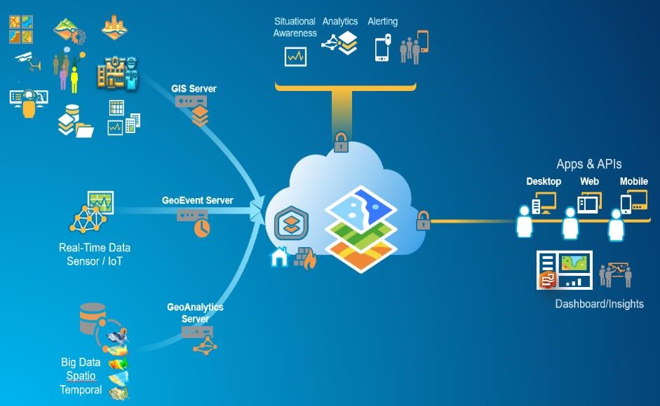
This diagram is an overview of what additional value Esri can bring to an SAP environment. The SAP-Esri story is quite complementary, with practically no areas where the two software suites compete. To dive into a bit more detail, these are areas that Zag will provide value:
Note that even though we are promoting Esri, we don’t only support Esri; Esri is our preference and we would love you to implement an Esri-SAP solution, but we are also realistic on this. If you want to use another development environment, then we can accommodate that too. We are familiar with all current GIS development environments out there.
The last part of this blog discusses Esri value-add in the context of fieldwork specifically. What tools are available for Esri users? Please look at the following diagram:
- Zag Spatial as a Service (ZaaS) – we provide full support for your spatial environment whether that is something small like occasional guidance on GIS best practices and how to best integrate SAP & Esri or a fully managed 24/7 spatial environment.
- GIS & Cloud Premium support – as both GIS and cloud specialists we can provide full end-to-end support across your whole spatial cloud platform.
- Reference Data services – do you know what local spatial reference data is available? And what reference data is available that is specific to your business needs? We can help you to source the best data available to you. Most of it’s usually free!
- ETL services – we can help you automate your data transformation processes and advise you where your current processes could be optimised.
- Self-Service for Business – a lot of organisations want to enable their users and business units with spatial self-service but don’t know how to do this without breaking something on their IT or GIS platform. Self-service is something our team is quite experienced on and can provide you with some quick wins to get you started.
- Search & Discovery Services – how do you enable your users to find out all the great spatial things you have enabled for them? With search and discovery services of course. Unfortunately, most of these are quite complicated and require GIS specialist skills to access, however, our team can enable your non-technical users with some simplified Google-like interfaces for people to find data, services, apps, documents and tools.
- Base map Services – there are a lot of base map services available, and most of them are free, but which ones work best for your business? Or do you need your own base map built and what would be the business benefits be for doing that?
- SAP Integration – how and what can you integrate with and what level of integration is possible? We have a team of experts across APAB, GEF and Esri JavaScript API who can help you get the most of the SAP-Esri integration.
- Custom Apps & Integration – if you need custom apps built, we have a development team who are confident with SAP, Esri and open source development.
- Advisory Services – we provide a wide variety of advisory services from helping you to decide what level of spatial do you need in your organisation, and how best to enable it, to full master data management plans and interfacing spatial with your Strategic Planning and Business Cases. Spatial is something we are passionate about and have been working on for many years.
Note that even though we are promoting Esri, we don’t only support Esri; Esri is our preference and we would love you to implement an Esri-SAP solution, but we are also realistic on this. If you want to use another development environment, then we can accommodate that too. We are familiar with all current GIS development environments out there.
The last part of this blog discusses Esri value-add in the context of fieldwork specifically. What tools are available for Esri users? Please look at the following diagram:
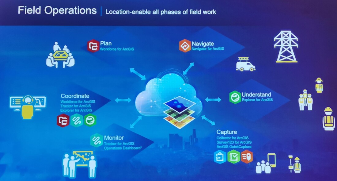
It lists all the current Esri mobile products and what they are used for, note that these products are part of the Esri platform offering and do not require separate licensing:
There are also some premium apps (that require separate licensing) available on Esri Platform like ArcGIS Insights, which is their Location Intelligence tool of choice, and Drone2Map which is an infield capture tool that allows the set up and capture of drone flight data into the data repository (Esri GeoDB).
Links and Esri Stuff
Finally, there are some links that I wanted to share with you on both SAP Spatial and on Esri to get some idea on what and how the spatial parts work.
Let’s start with SAP-Esri links:
Then some Esri links to see how spatial can be used:
- Explorer for ArcGIS is a generic map viewer tool to better understand your spatial data available as a native mobile app for both Apple iOS and Android.
- Navigator for ArcGIS is a native iOS/Android app that allows you to find the best route (or traveling salesman algorithm) for your fleet.
- WorkForce for ArcGIS is a native iOS/Android app that allows you to plan your workforce allocation in the field and that workforce to capture the work done.
- Tracker for ArcGIS is a native iOS/Android app that can follow your workforce device and record the XY while they are on the move. It’s great for Health & Safety and improves your knowledge of where your staff are located.
- Collector for ArcGIS is a native iOS/Android app that allows field capture of your assets and their statuses.
- ArcGIS QuickCapture is a simple native iOS/Android app that allows crowd-sourcing and notifications with one press of a button from locations and photos.
- Survey123 is a cross-platform app that can be used to take quick surveys in the field.
- Operations Dashboard is a management level monitoring web app that can be used to monitor your work Force in the field.
There are also some premium apps (that require separate licensing) available on Esri Platform like ArcGIS Insights, which is their Location Intelligence tool of choice, and Drone2Map which is an infield capture tool that allows the set up and capture of drone flight data into the data repository (Esri GeoDB).
Links and Esri Stuff
Finally, there are some links that I wanted to share with you on both SAP Spatial and on Esri to get some idea on what and how the spatial parts work.
Let’s start with SAP-Esri links:
- SAP HANA/Esri Story Map for 311 calls
- Esri landing page for SAP HANA
- Sapphire 2019 Innovation Winner – MunichRE Risk Suite
Then some Esri links to see how spatial can be used:
- How We Mess Up Our Global Weather:
- 3D Because That is our Future (Data):
- And Some Others …
