Future of SAP and Spatial and why should you care? Part 1
Back in November 2018 on a windy Wellington evening, Warrick (Chief Innovation Officer for Zag) and I were having a chat about Zag and Spatial and the potential opportunity for Zag to do something with spatial industry and functionality within the business. Wellington is famous for its great coffee, so of course this kind of world domination brainstorming required a great setting (Moss Café downstairs of Zag) and several mugs of the good stuff, and the end game was that we believed there were some real good opportunities to build spatial capability within Zag.
Fast forward several months with multiple meetings fine tuning what this could mean, some planning on what areas of spatial Zag could target and some 3-5-year budgeting involving more Chiefs and more brain storming. At this point we started to get a real good picture of the whole “spatial thing” and a feeling that this could really be something unique, transformational and potentially game-changing for New Zealand and Australia.
July 1st, 2019, we started the brand-new Spatial line of business in Zag and it has been a great ride so far. So, to widen the knowledge on spatial, we are publishing a series of three Blog posts (in two parts each), which this will be the first part of the first post. These blog posts are going to be in consequential order starting from not so technical, getting more technical and eventually bringing in the latest changes and news. I hope you enjoy these posts!
Introduction to Spatial
So, let’s start with some simplified definitions on what we mean with Spatial (aka GIS);
So, let’s start with some simplified definitions on what we mean with Spatial (aka GIS);
|
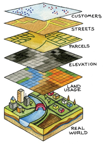
Spatial is all about map layers made with core (business) and reference data:
|
There is also spatial analytics; Location Intelligence, that is basically a subset of Business Intelligence, Analytics and Enterprise Reporting – and is used for specialist spatial analysis tasks like Retail Outlet/Site Planning, Truck/Vehicle Route Optimisation, Officer/Staff Safety (using GPS), Workforce and Vessel Monitoring, Trade and Market Analysis, Customer Segmentation, Time Series etc.
Another important aspect of spatial we talk a lot about is Self-Service, which is part of Spatial as a Service – and is there for providing business units the capability to create their own apps and data and publish it for their customers/users without dedicated support or services from IT or GIS teams. Key component of Self Service is to comply with IT Best Practices and with all the GIS standards and master data management rules.
And then there is integration with IT and Business systems, which is also where SAP fits into the picture; providing some standards-based tools to integrate GIS into various enterprise products embedded as part of the interface – maybe as a tab or a frame in the screen, or just another chart card on the dashboard, or included in a report to provide the geographical content. GIS should be used as just another way to view the enterprise data.

|
GIS used to be Dark Art – a bunch of propeller heads in a backroom asked to produce maps for the executive reporting or specialist analytics as part of a customer project; sometimes publishing a paper map, or providing map-centric silo interfaces trying to fit in as much data (layers) and tools as possible
– and trying to provide users a kind of one-stop-shop; full on toolkit that could be used to just viewing the data geographically to complex manipulation and trend analytics. |
Luckily those days are gone, as it did not really work; it was quite costly to build these generic products, but users also found them real difficult to use; you needed specialization skills, complicated manuals and training to get most out of these tools.
Today a GIS Team is like any other IT team, right? Well not quite – they do have their own lingo and tend to not be understood by others. It is a typical scenario that IT support claims GIS team does their own things (Shadow IT), GIS team complains IT does not understand them and just tries to hinder their work and Business does not understand either teams and wonders why everything takes so long to do and seems to be so complicated and so on. Spatial isn’t special, but the terminology seems to be. This is where Zag Spatial can help – as the co-between people who can “translate” the lingo between the various teams. And in some cases, even managing the spatial platform by complying with IT standards and best practices, providing efficient self-service capability to the business units and master data management for the GIS team.
Today a GIS Team is like any other IT team, right? Well not quite – they do have their own lingo and tend to not be understood by others. It is a typical scenario that IT support claims GIS team does their own things (Shadow IT), GIS team complains IT does not understand them and just tries to hinder their work and Business does not understand either teams and wonders why everything takes so long to do and seems to be so complicated and so on. Spatial isn’t special, but the terminology seems to be. This is where Zag Spatial can help – as the co-between people who can “translate” the lingo between the various teams. And in some cases, even managing the spatial platform by complying with IT standards and best practices, providing efficient self-service capability to the business units and master data management for the GIS team.

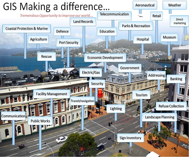
Geospatial is integrated into everything; to showcase value of knowing where your customers are, what types of services are available in which locations, how to get from point to point fastest etc. Your IT data analysts and developers can enable and integrate spatial independently as GIS now use same standards and frameworks as IT.
|
Specialists vs Generalists – spatial is no longer purely a specialist industry, it is part of the standard IT now.
The opposite to traditional map viewers is happening; it is all about user stories and simplified interfaces; if I have a specific job that requires a map with 2 tools and 3 layers of data, then why do I need to access these through complicated interfaces and multiple mouse clicks? Or (as a study says happens on 65% of cases) if the map is only part of the story (like linking my query geographically to an area or entities on a location) and the end result is information that I need to attach on a report or a dashboard, why do I have to use additional tools to copy-paste the information out of a map viewer into my end goal publication? |
When considering the IT industry and how IT is used, we always look at the WHY (reasons for my business), the WHAT (the ways we serve our customers), the HOW (what tools are in place?) and the WHEN (are we improving across time?). When considering Spatial we just add in the WHERE component into the mix (does geography have an impact for my business?).
|
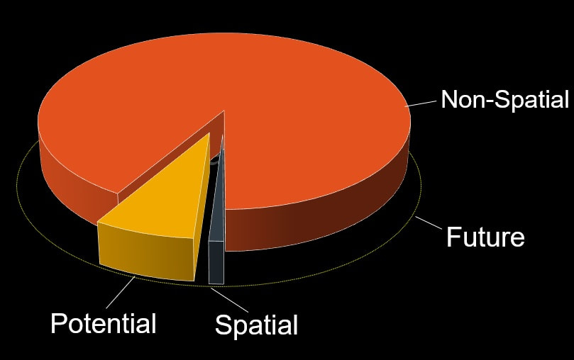
In 1987 a study was done by Ohio university that showed that location is across all data and solutions as a component. In 2002 Wikipedia tested their documents and found out that 82% of the documents had a spatial component.
The Spatial industry is not a silo industry – it is part of all other industries; a small part, but sometimes it’s the “tail wagging the dog”. |
Unfortunately the spatial industry is not realising its potential; Spatial is finding it tremendously difficult to involve other industries, mainly because it is a very insular industry; just visit a spatial conference – any one of them – and you always meet the same people; it is basically spatial people preaching to spatial people, there are very few representatives from other industries involved.
|
|
SAP with Spatial
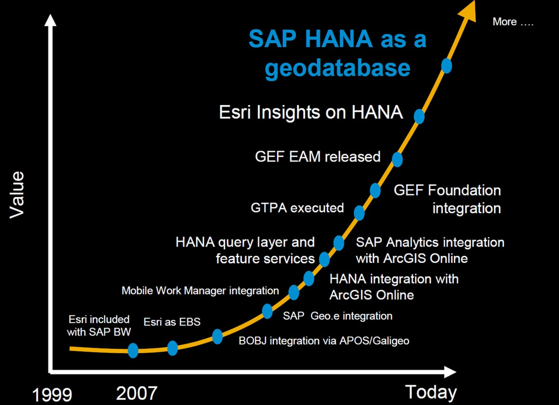
This is not SAP’s first “Spatial Rodeo”; SAP already has over 20 years of spatial expertise with 27 global partners in spatial industry.
This is not SAP’s first “Spatial Rodeo”; SAP already has over 20 years of spatial expertise with 27 global partners in spatial industry.
|
SAP and Esri have a joined technology integration roadmap to work together building services that complement each other; Esri was the 2018 SAP Pinnacle Award Winner "SAP Global Partner of the Year”.
|
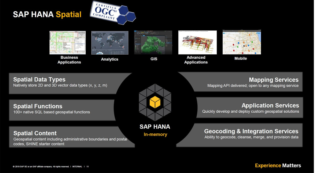
SAP HANA is natively spatial; it supports Open Geospatial Consortium (OGC) standards with all relevant spatial data types (2D, 3D and 4D) and functions. SAP HANA Spatial has been integrated already to several business applications (via GEF SAPUI5 and Fiori), into SAP Business Objects (via BOBJ), and with some mobile apps. SAP HANA is now also supported by Esri as an Enterprise GeoDB; and as such enables ALL the Esri GIS and advanced products.
There is a whole lot of spatial content enabled as part of the SAP Directories like addresses and postcode boundaries, as well SAP provided services for mapping, geocoding, validation, cleansing, APIs and application services.
There is a whole lot of spatial content enabled as part of the SAP Directories like addresses and postcode boundaries, as well SAP provided services for mapping, geocoding, validation, cleansing, APIs and application services.
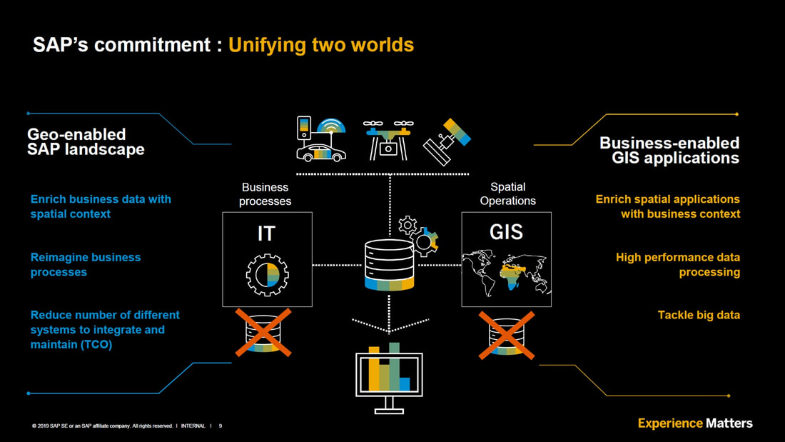
SAP is committed to join the two worlds; SAP landscape and GIS landscape. There is one central source of truth for all data whether it is core business data, core spatial data or spatial reference data; no need for additional databases on either side, just tables joint on the HANA instance. This is expected to improve the efficiencies across GIS team support up to 70% per support person.
Also, worth noting are the devices on top of the diagram accessing HANA without need for apps or User Interfaces – this is based on services-based access, and often has no need for a map at all. This is how we would enable AI/ML (Artificial Intelligence, Machine Learning) to access and manipulate spatial reference data to create value-add on these datasets as well as deriving vector data from raster (aerial/satellite imagery).
Analytics is also accessed directly from the one source of truth; this means there will be no possibility for users or analysts interpreting the results, as transactional business systems will share the same currency as the reporting and querying analytics software does.
Note that there is at least one other scenario not shown on this diagram and that is the self-service enablement for Business and non-specialist users – also available from the same source of truth because of this unification.
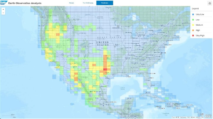
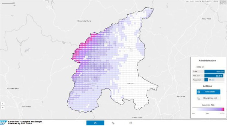
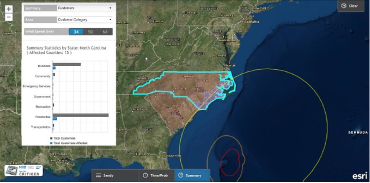
SAP HANA is certainly becoming a game-changer; there are already over 31,000 customers using this in-memory platform. Let’s consider some specific Case Studies:
|
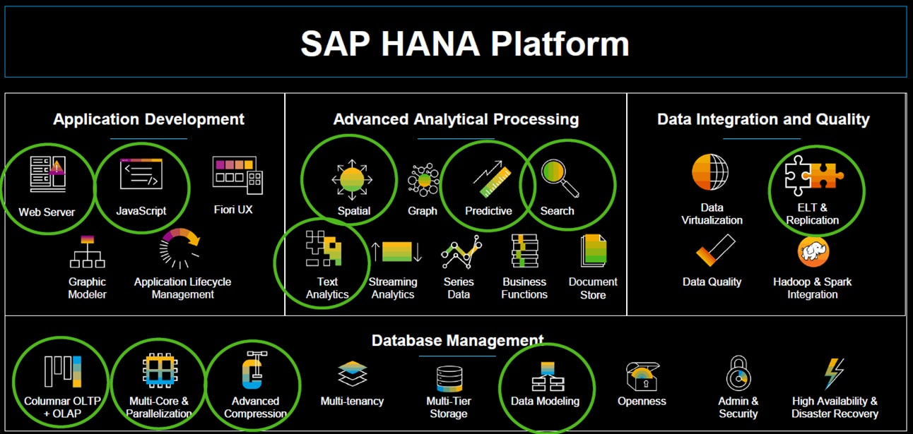
If we look at the HANA platform and pick up a use case from the Agri industry; like Vegetation Management, we can look at the tools used across the different SAP HANA Platform groups and what is needed to enable this user story.
A hybrid future-ready Vegetation Management requires quite a lot of these new tools to make a difference. |
|
Consider also the spatial services provided by the HANA platform and how we could come up with new products like:
|
|
|
|
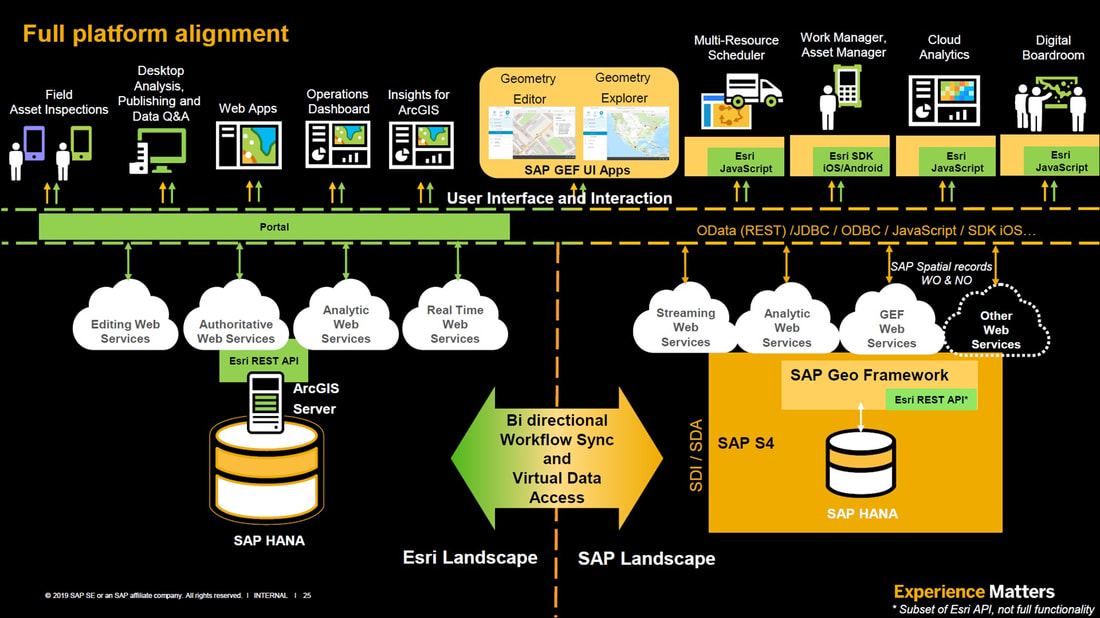
So how are SAP and Esri working together? Consider the full platform alignment diagram below;
On the right side we have the SAP S/4HANA platform enabling GIS via GEF web services and APIs via Geometry Editor and Geometry Explorer, on the left side we have the full Esri product suite platform also using HANA as an Enterprise Esri GeoDB and enabling GIS via RESTful web services. This gives users the best from both worlds; spatially enabled comprehensive business suite from SAP and 100+ advanced GIS products from Esri, all providing uniform experience to the users branded to the company requirements, workflows and needs.
On the right side we have the SAP S/4HANA platform enabling GIS via GEF web services and APIs via Geometry Editor and Geometry Explorer, on the left side we have the full Esri product suite platform also using HANA as an Enterprise Esri GeoDB and enabling GIS via RESTful web services. This gives users the best from both worlds; spatially enabled comprehensive business suite from SAP and 100+ advanced GIS products from Esri, all providing uniform experience to the users branded to the company requirements, workflows and needs.
More on this in my next PART 2 blog post of - “PART 2: The Undiscovered Country” …
